Overview
The trek starts from Ghuttu and moves parallel to River Bhillangna. You cross the Mayali pass at approximately 5300 meters above MSL. The trek offers an extraordinary experience of Indian Himalayas. The remote Indian villages of Gangi, bear-infested forests, Sahastra Taal, Kush kalian plateau, Masar Taal, views of the peaks on the southern side of the Gangotri glacier, Bhilangna river Catchment, Thalay Sagar peak, Khatling glacier are the highlights of Mayali Pass trek. Taking you through ascents and descents, rocky moraines, narrow trails, crevassed glaciers and demanding landscapes, the imposing Mayali Pass Trek is meant for experienced trekkers only with high physical and mental endurance. The best time to do this trek is in the months of June and September. Stay on this page for more information on the Mayali Pass Trek with detailed itinerary
11 Days / 10 Nights
6-15 persons
Highest Point 5300 Mtr
Short Itinerary
Day 01: Dehradun to Guttu - 140 km Drive
Day 02: Guttu to Reeh - 10 km
Day 03: Reeh to Gangi - 12 km
Day 04: Gangi to Kharsoli - 15 km
Day 05: Kharsoli to Chowki - 12 km
Day 06: Rest and Acclimatization
Day 07: Chowki to Masar Tal (14960 ft) - 8 km
Day 08: Masar Tal to Vasuki Tal (14435 ft) via Mayali Pass (16900 ft) - 12 km
Day 09: Vasuki Tal to Kedarnath (11800 ft) - 7 km
Day 10 : Kedarnath to Gaurikund (6530 ft) - 18 km
Day 11: Depart from Gaurikund
Itinerary
Day 01: Dehradun to Guttu - 140 km Drive
Report at the Dehradun from here catch your bus or taxi for Ghuttu Village for night stay.
Day 02: Guttu to Reeh - 10 km
Start trek from Ghuttu. Initially you walk on the dirt road . If the sun is up it could become very hot. Try to cover this part in the early morning hours . Afterwards you walk in the forest upto Reeh. Initially the trail is mostly parallel along the river and later it’s a climb through the pine forest. Enroute you will see Rhododendron and bamboo trees . Pitch camps in Reeh . Ovenight stay in camps.
Day 03: Reeh to Gangi - 12 km
Start from Reeh after breakfast .Today's target is to reach Gangi. Gangi is a remote village of strong cultural heritage. Today's trek is mostly a gentle climb with a steep section towards the end of the trek.
Day 04: Gangi to Kharsoli - 15 km
Intially there is some stretch where landslides are common. Be careful while crossing this section. A short climb from here & you reach Kalyani. Kalyani is a plane ground . Reach Kharsoli by late after noon .Kharsoli can be identified by a Nallah confluencing with Bhilanganga river. Camp in Kharsoli.
Day 05: Kharsoli to Chowki - 12 km
Today, we will start from Kharsoli and reach Chowki Campsite. It is a lovely green meadow surrounded by snow clad crest. Today' camps are by the side of Doodh Ganga River with the Khatling glacier in the distance.
Day 06: Rest and Acclimatization
We are already at 4000 M . Today is an acclimatisation day as the altitude gain will be significant on the coming days . During the day we can go to the Khatling glacier and return to camp.
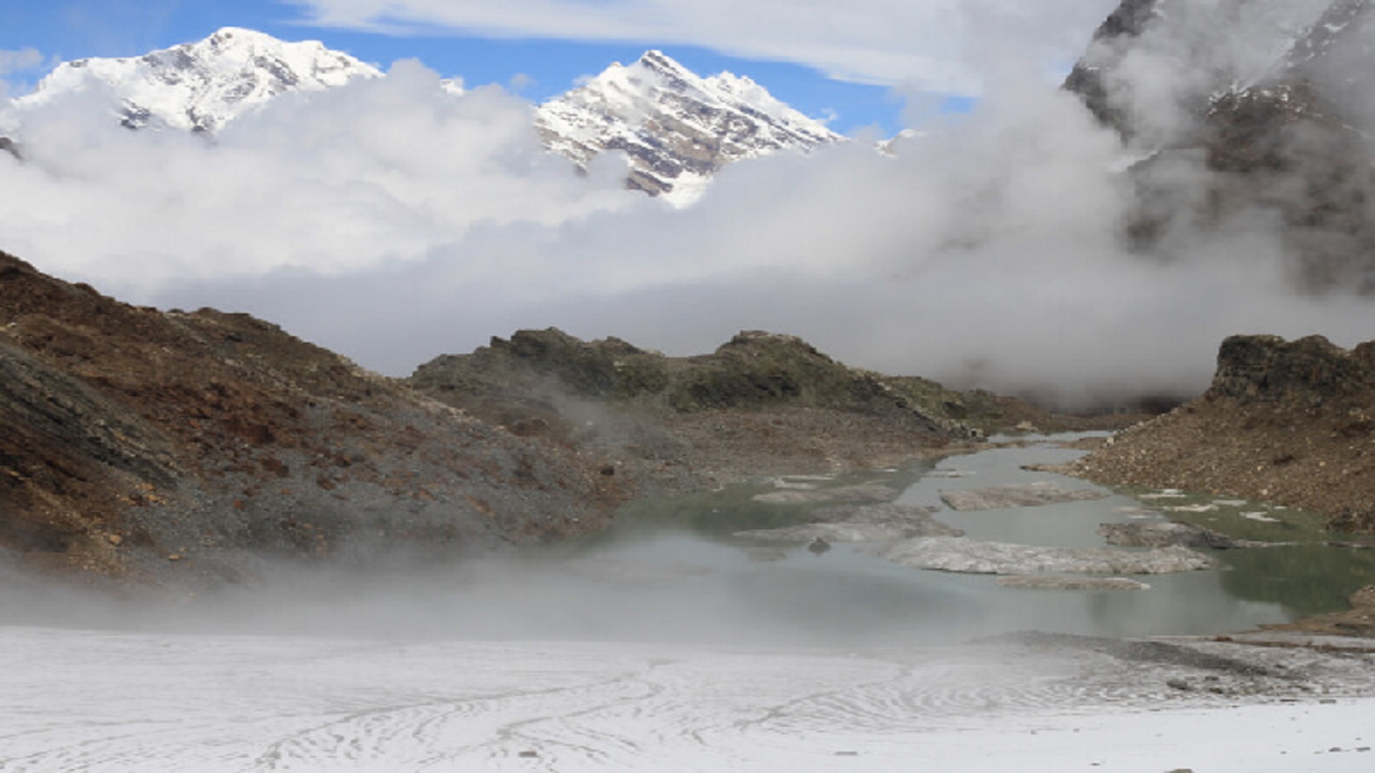
Day 07: Chowki to Masar Tal (14960 ft) - 8 km
Initially we will ascend a steep section with views of Thalay Sagar and cross a ridge above the valley. The route is well defined as we approach the beautiful Masar Tal. After reaching the site, we will pitch our tents near the scenic lake.
Day 08: Masar Tal to Vasuki Tal (14435 ft) via Mayali Pass (16900 ft) - 12 km
Today’s trail begins with a steep ascent over boulders on a steep ridge to Masar top. Then the path descends slightly before climbing up the glacier to the top of Mayali Pass. The descent from Mayali Pass is fairly steep, similar to Auden’s Col on Khatling side, and may require fixing rope and rappelling. Continue the descent all the way to Vasuki Tal.
Day 09: Vasuki Tal to Kedarnath (11800 ft) - 7 km
Today, we will start our trek towards the Kedarnath, the famous pilgrimage site. Kedarnath is 7 km from Vasuki Tal and it takes around 3-4 hrs to reach there. The temple is dedicated to Lord Shiva and is one of the twelve jyotirlingas located in India. After reaching there, we will visit the temple in the evening. Overnight stay in the hotel at Kedarnath.
Day 10 : Kedarnath to Gaurikund (6530 ft) - 18 km
We will descend through the well laid path of 18 kms, which takes us to the Gaurikund. Overnight stay in Guest house in Gaurikund.
Day 11: Depart from Gaurikund
Inclusion
From Day 1 through Day 11 of your walk, you will be sleeping in various hotels and tents.
All meals are provided, beginning with the first night’s dinner and ending with breakfast on day five. On all days of the walk, we provide simple, healthy vegetarian meals.
Trekking permits and camping expenses in the woods are all accounted for.
Tents and sleeping bags of the highest quality will be provided at each camp. Fortunately, we have high-altitude sleeping bags that are good down to ten degrees Celsius.
Gaiters, microspikes, and ropes are available.
Exclusion
Costs associated with carrying personal items, such as luggage, on the hike.
The term “emergency costs” refers to any and all costs that crop up as a direct consequence of a crisis.
There will be no access to bottled water at any point throughout the walk.
Cost of transportation from Dehradun to Natin (Raithal) (between 1000 and 1500 INR)