Overview
Auden’s Col is the holy grail of trekking in the Western Himalayas - hailed by many as being more difficult than Kalindi Khal, which is one of the most dangerous treks in India. As a mountain pass hanging at the impressive altitude of 5,490M, this impossibly high, glaciated pass between the ginormous Gangotri and Jogin massifs is the climax of a long, treacherous journey between the pilgrimage towns of Gangotri and Kedarnath.
Starting from the high mountain town of Gangotri, which is possibly one of the best trailheads in the country, the trek takes you high in the Garhwal Himalayas in the massive Gangotri glacial region. The mighty Bhagirathi flows loud and proud, from its glacial source at the foot of Chaukhamba, down through vast meadows and dense deodar forests. Auden’s Col is by no means a monotonous landscape. You climb through dense birch and oak forests on the first day, onto vast, unending meadows with panoramic views of the Gangotri and Jogin peaks. You leave the meadows for harsh, alpine terrain - over moraine fields with hidden lakes, onto steep snow slopes for the final pass climb. Once you climb the pass, you walk through one of the most heavily glaciated regions in India - the crevassed Khatling glacier. Then back onto moraine and through dense forests once again before visiting the holy Vasuki Tal lake and the snow-covered Mayali Pass.
The first crossing of Auden’s Col, through this beautiful trail which links the Khatling and Rudra valleys was made by J.B. Auden, a British surveyor, in the year 1939 with the next recorded passing of the col, a long 44 years after. With everything that’s challenging and awesome about Auden’s Col - the glaciated approach, the lush and beautiful lower valleys, the unending moraine, and the magnificent views, the pass remains one of the least explored in the country even today.
On the one hand, the trek is an easy pick for its scanty crowds and a perfect assortment of beautiful landscapes along with unmatched views of revered peaks in the range. But on the other hand, it is feared to be a hostile trail where the dangers encountered outweigh the scenic beauty of the terrain. For the distance covered and altitude gained each day, there are no ‘easy’ days here. The trek requires immense patience, and doesn’t forgive those who don’t acclimatize well.
That being said, this trek brimming with raw beauty and laborious challenges, is perfect for seasoned trekkers looking to step up their trekking game in the Himalayas.
15 Days / 14 Nights
6-15 persons
Highest Point 5490 Mtr
Short Itinerary
Day 01: Arrive at Gangotri (3,415M)
Day 02: Rest and acclimatization at Gangotri (3,415M)
Day 03: Gangotri (3,415M) to Nala Camp (3,760M)- 7 km
Day 04: Nala Camp (3,760M) to Rudugaira Camp (4,350M) - 04 km
Day 05: Rest and Acclimatization at Rudugaira Base Camp (4,350M)
Day 06: Rudugaira Base Camp (4,350M) to Auden's Col Base Camp (4,720M) via Gangotri Base Camp (4,500M) - 08 km
Day 07: Auden's Col Base Camp (4,720M) to Khatling Glacier Camp (5,000M) via Auden's Col (5,490M) - 05 km
Day 08: Khatling Glacier Camp (5,000M) to Zero Point (3,870M) - 10 km
Day 09: Rest Day at Zero Point (3,870M)
Day 10 : Zero Point (3,870M) to Chowki (3,580M) - 07 km
Day 11: Chowki (3,580M) to Masar Tal (4,135M) - 08 km
Day 12: Masar Tal (4,135M) to Vasuki Tal (4,135M) via Mayali Pass (5,000M) - 12 km
Day 13: Vasuki Tal (4,135M) to Kedarnath (3,590M) - 07 km
Day 14: Vasuki Tal (4,135M) to Kedarnath (3,590M) - 14 km
Day 15: Gaurikund (1,985M) to Dehradun (430M) - : 252 km Drive
Itinerary
Day 01: Arrive at Gangotri (3,415M)
The only way to reach Gangotri is by road. You should reach by 3 PM. One can start the road journey either from Dehradun or Rishikesh but with a new route open now, reaching Gangotri via Dehradun is the faster option (around 242 Kms). You will receive the detail of accommodation in Gangotri through an email from us. After reaching here, check into the Guest House/Hotel. Have some rest. The evening can be utilized to explore the local market, temples, etc.
Day 02: Rest and acclimatization at Gangotri (3,415M)
Rest & Acclimatisation in Gangotri.
Day 03: Gangotri (3,415M) to Nala Camp (3,760M)- 7 km
Our first day of trekking in this treacherous terrain involves an altitude climb of close to 350M. The trail for most parts runs through dense forests that occasionally open up to miniature grasslands with unclouded views of limpid skies above.
We head southwest from Gangotri, walking down the main valley for around 2 km and then turn east into the Rudugaira valley. The trail from here gradually climbs up through thick oak and birch forests. On crossing the nala, the tree line begins to thin out giving way to wider expanses of landscape in the form of meadows and grazing grounds. Our approach to the campsite for the day offers magnificent views of Gangotri III and Jogin II which looks like a sharks fin when viewed from a certain angle.
On reaching the campsite, we rest our weary selves for a bit, get some fuel in the form of hot food and head out for an acclimatization walk early evening.
Day 04: Nala Camp (3,760M) to Rudugaira Camp (4,350M) - 04 km
On the agenda today is a 600M altitude gain across a short distance of 4 kms. Needless to say, the ascent up to Rudugaira Base camp will be steep and grueling. Going further ahead from the Nala Camp, the trail climbs to the upper grazing grounds which, if you are lucky, will offer up countless herds of Bharal (Himalayan Mountain Goats) sprinting around these high mountain lands. After crossing a few streams, we begin our climb up a steep spur which will take us straight to Rudugaira Base Camp.
We pitch our tents in this beautiful campsite covered in snow and surrounded by famous peaks such as Gangotri I, II, III and Jogin III.
Day 05: Rest and Acclimatization at Rudugaira Base Camp (4,350M)
Today is reserved for acclimatization to the altitude since we gained quite a bit of height in the last two days and have also entered a much different terrain. After a late breakfast we go for an acclimatization walk. On climbing just a few hundred meters from the campsite, we get our first view of Auden's Col which is inspiring to say the least. We end the day early so as to get optimum rest.
Day 06: Rudugaira Base Camp (4,350M) to Auden's Col Base Camp (4,720M) via Gangotri Base Camp (4,500M) - 08 km
Today we start early and continue on towards Gangotri base camp which is approximately 4 kms from our campsite. A short while into our trek, we get our first glimpse of Auden’s Col. The view is absolutely spectacular. Covered in white, the col appears benign as it straddles a precarious ridge from the mighty Jogin I on the east and an equally formidable ridge running from the Gangotri III peak on the North West.
Gangotri base camp to Auden's Col base camp is a relatively short walk of 4 km, but quite difficult due to the altitude, terrain, and snow we have now left the slopes of the valley behind and have entered the world of moraines. After a few hours of trudging through moraine-covered snow, we reach the wild and desolate Auden's Col base camp. On our way today, we will pass a high-altitude lake by the name of Sukha Tal which is a beautiful azure lake hidden in a moraine bowl.
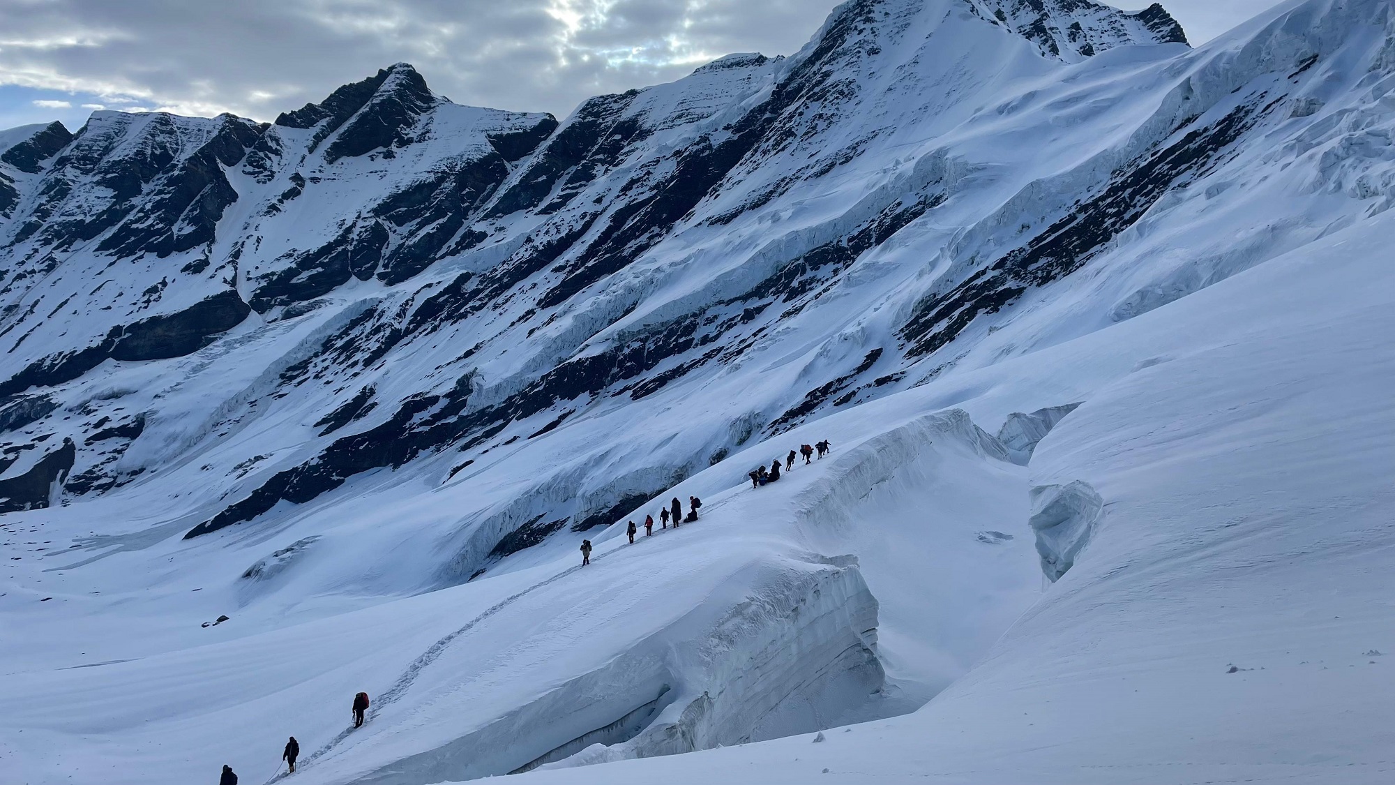
Day 07: Auden's Col Base Camp (4,720M) to Khatling Glacier Camp (5,000M) via Auden's Col (5,490M) - 05 km
Today is THE day. We will be crossing the formidable yet spectacular Auden’s Col which lies at the confluence of four huge massifs: Jogin I and Gangotri III flanking us on either side with the Jogin glacier behind us and Khatling lying in front of us. Expect this to be a tiring day.
We continue on the moraine-ridden terrain until we reach the glacier. After a short while on the glacier, we hit a patch of ascent with a gradient between 30-50 degrees which will need to be navigated with caution. We rope up for this steep patch, which spans close to 1.5 kms, for utmost safety. The climb up to the col should take close to 3 hours. However, the climb up is not the main challenge for today.
The descent from the col is tricky and requires navigating a steep and narrow gully inclined at an angle of 70-75 degrees. Once this gully is crossed, however, the glacier flattens out – the broadened valley giving way to views of massive icefalls, glaciers and formidable peaks in the region. A short walk down the glacier brings us to our camp for the night.
Day 08: Khatling Glacier Camp (5,000M) to Zero Point (3,870M) - 10 km
We have successfully crossed the pass and are now on the other side, but the challenge has only just begun. Today is going to be one of the longest days of the expedition and also the most demanding. We will be crossing the forbidding Khatling glacier today, which is almost 10 kms long and extremely challenging to navigate. As one of the most heavily glaciated regions in India, the Khatling glacier is a moraine-rich land full of hidden, open and deep crevasses for all the 10 kms. This unmarked route over loose gravel and scree with sections of steep ascents and descents demands extreme caution with each step forward. Towards the end, we are reunited with a marked trail which leads us to our campsite for the day by the snout of the Khatling glacier
Day 09: Rest Day at Zero Point (3,870M)
Since the last couple of days have been extremely taxing, we rest at Zero Point today.
Day 10 : Zero Point (3,870M) to Chowki (3,580M) - 07 km
Today we will be leaving the land of snow and making own way to the warmer reaches of the valley. After 3 kms of continuing our walk along the river, we reach the meadows. Chowki, our grassy campsite after spending days in rocks and snow, is a 4 km walk from here.
Day 11: Chowki (3,580M) to Masar Tal (4,135M) - 08 km
We will be making our way to one of the most isolated lakes in the Garhwal region, Masar Tal, today. Stationed at an altitude of 4,135M, this pristine, high-altitude lake rests to the east of the snowy Khatling glacier. The route starts off as a steep ascent with a view of Thalay Sagar- a gorgeous peak of 6,904M that lie 10 kms southwest of the holy site of Gaumukh. After the initial ascent, we cross a ridge over the valley which takes us straight to Masar Tal. We camp by this scenic lake.
Day 12 : Masar Tal (4,135M) to Vasuki Tal (4,135M) via Mayali Pass (5,000M) - 12 km
Onwards to another glacial lake today, Vasuki Tal is at an altitude of 4,135M. Today’s trail begins with a steep ascent over boulders on a ridge to Masar Top. The path, then, descends slightly before climbing up the glacier to reach the top of Mayali Pass – another hidden gem of Uttarakhand. The descent from here is as precarious as the one we left behind when we climbed down from Khatling glacier. This section will require the use of fixed ropes on which we will rappel down. We continue our descent down all the way to Vasuki Tal which is our campsite for the day.
Day 13: Vasuki Tal (4,135M) to Kedarnath (3,590M) - 07 km
We will finally be making our way to Kedarnath today – which happens to be one of the holiest shrines to Shiva. As one of the twelve Jyotirlings, Kedarnath sees a lot of pilgrims in the months when the area is not buried under snow. Kedarnath is a 7 km trek from Vasuki Tal which takes about 3-4 hours to cover. We visit the temple in the evening and spend our night in a warm bed in a hotel, after days on cold, uneven surfaces.
Day 14 : Vasuki Tal (4,135M) to Kedarnath (3,590M) - 14 km
We trek down this easy, well-marked trail of 14 kms which takes us directly to Gaurikund. We will be spending our night in a guesthouse/hotel.
Day 15 : Gaurikund (1,985M) to Dehradun (430M) - : 252 km Drive
The drive back down to Dehradun is alongside the fierce Ganga River. It should take close to 9 hours to reach. Expect to get to Dehradun by late evening.
Inclusion
From Day 1 through Day 15 of your walk, you will be sleeping in various hotels and tents.
All meals are provided, beginning with the first night’s dinner and ending with breakfast on day five. On all days of the walk, we provide simple, healthy vegetarian meals.
Trekking permits and camping expenses in the woods are all accounted for.
Tents and sleeping bags of the highest quality will be provided at each camp. Fortunately, we have high-altitude sleeping bags that are good down to ten degrees Celsius.
Gaiters, microspikes, and ropes are available.
Exclusion
Costs associated with carrying personal items, such as luggage, on the hike.
The term “emergency costs” refers to any and all costs that crop up as a direct consequence of a crisis.
There will be no access to bottled water at any point throughout the walk.
Cost of transportation from Dehradun to Natin (Raithal) (between 1000 and 1500 INR)